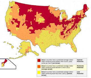
Radon is a naturally occurring radioactive gas that can seep into homes and buildings from the soil, posing serious health risks to occupants. Radon levels can vary significantly from one location to another, making it essential for homeowners to understand radon maps to assess the radon risk in their area. In this article, we'll explore what radon maps are, how they work, and why they're important for protecting your family's health.
What are Radon Maps? Radon maps are geographical representations that depict the distribution of radon gas concentrations across different regions. These maps are typically based on data collected from radon measurement surveys conducted in various areas. By analyzing factors such as soil composition, geology, and historical radon test results, experts can create radon maps to estimate the likelihood of elevated radon levels in specific locations.
How Radon Maps Work: Radon maps use color-coded scales to indicate the relative radon risk levels in different areas. Generally, areas with higher radon concentrations are depicted in darker shades, while lower-risk areas are shown in lighter shades. These maps can be national, regional, or local in scope, providing homeowners with valuable insights into the radon risk in their vicinity.
Why Radon Maps Matter: Understanding radon maps is crucial for several reasons:
-
Awareness: Radon maps raise awareness about the prevalence of radon gas in different regions, helping homeowners recognize potential risks and take proactive measures to mitigate radon exposure.
-
Risk Assessment: By consulting radon maps, homeowners can assess the radon risk in their area and determine whether radon testing is necessary to ensure the safety of their homes.
-
Prioritizing Testing: Radon maps can help prioritize radon testing efforts, directing resources toward areas with higher radon potential and guiding public health initiatives aimed at reducing radon exposure.
-
Policy and Regulation: Radon maps inform policy and regulation related to radon mitigation and building codes, influencing decisions on radon-resistant construction practices and public health initiatives.
How to Use Radon Maps: To utilize radon maps effectively, homeowners can follow these steps:
-
Access Radon Maps: Radon maps are available from various sources, including government agencies, environmental organizations, and radon mitigation professionals. Online resources such as the Environmental Protection Agency (EPA) website provide access to national and state-specific radon maps.
-
Interpret Map Data: Review the radon map for your region and identify areas with elevated radon risk based on the color-coded scale. Pay attention to factors such as geological features and local radon measurement data to better understand the radon potential in your area.
-
Take Action: If your area is identified as having elevated radon levels, consider conducting radon testing in your home to assess indoor radon concentrations. If test results indicate elevated radon levels, implement radon mitigation measures to reduce radon exposure and protect your family's health.
Conclusion: Radon maps are valuable tools for assessing radon risk and guiding proactive measures to mitigate radon exposure. By understanding how radon maps work and using them to assess the radon risk in your area, you can take decisive action to safeguard your home and family from the dangers of radon gas. Stay informed, prioritize radon testing, and take steps to reduce radon levels to create a safer indoor environment for everyone.

